The Ventura Percolation Basin Recharge Project is a pilot project that uses recycled water to perform controlled recharge experiments to quantify the basins recharge capabilities between basins with different soil types. The results highlighted the difference between a basin composed of silty sands and clays (P9 north end with sands to the south) versus a basin that consisted of sands with little silt (P10). We used electrical resistivity tomography (ERT) and electromagnetics (EM) to characterize the soil heterogeneity (in 3D) and point sensor placement (soil cores, soil moisture, permeability, thermal probes, water level, etc). The ERT and point sensors were then collected temporally to monitor subsurface water movement and measure/estimate hydraulic properties.
The percolation basin pilot study was conducted at the Moorpark Reclamation Facility in Moorpark, CA and is operated by the Ventura County Public Works department. This study was in collaboration with Ventura County Public Works, Calleguas Municipal Water District and funded by the Metropolitan Water District of Southern California’s Future Supply Action funding program. The goal of the project was to monitor how deep the applied water traveled into the subsurface, if it migrated directly into the river, estimate the recharge rates and provide (if any) information on the potential to improve recharge rates.
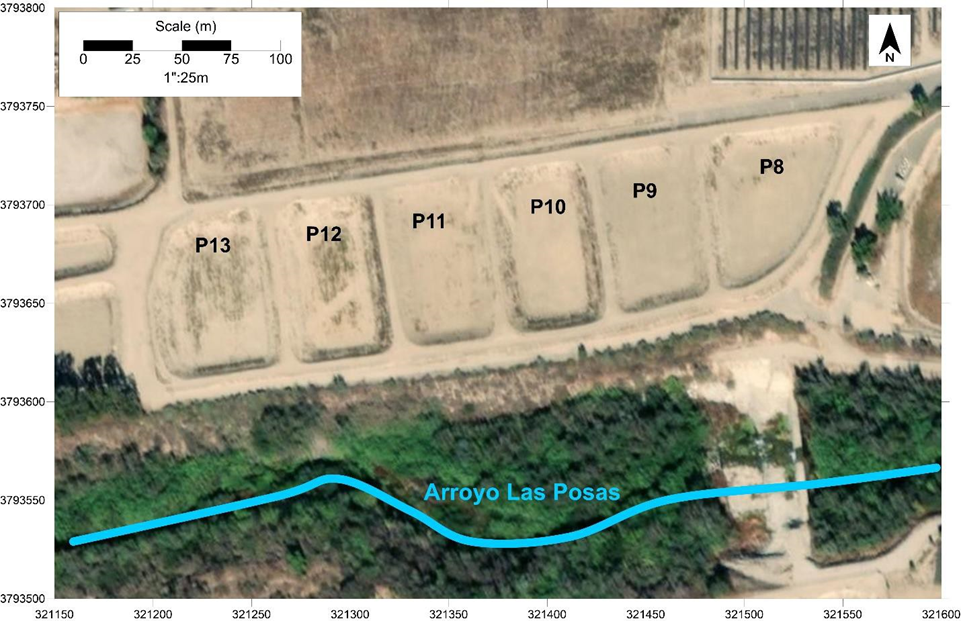
Six ponds (~2100 m2) were characterized with electromagnetic induction geophysics to evaluate the surficial soil (0-2m) in order to down-select two ponds that were further characterized for the recharge experiment.
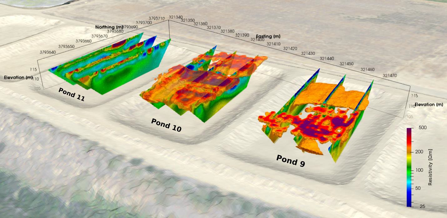
Ponds 9 and 10 were selected for the recharge experiment due to the contrasting soil types between the ponds but also within the ponds. These soils consisted of fine grain low permeability clays to coarse clean high permeability sands. Ponds 9, 10 and 11 were characterized to a depth of ~20m below the ponds.
This characterization data was used for the placement of soil borings, permeameter, neutron probe, pressure, and soil moisture measurements to capture the variations in soil physical and hydrological properties to be included in later modeling.
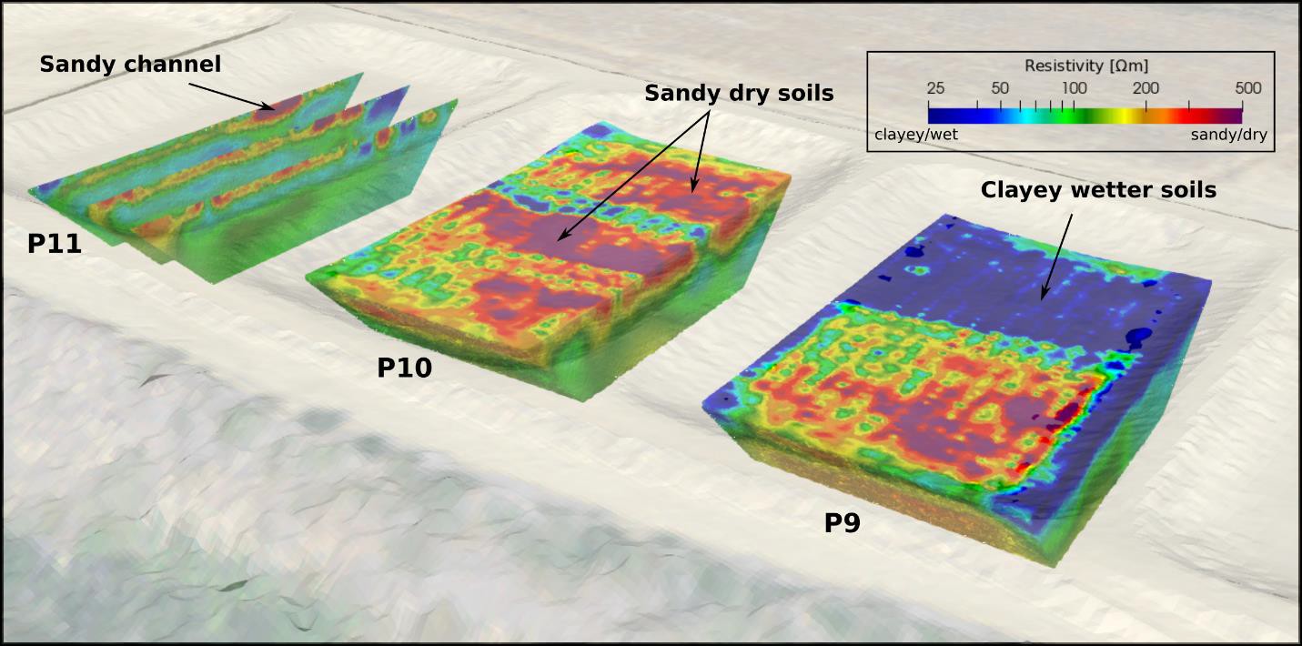
Recycled water was applied as a proxy or in leu of diverted surface water in summer of 2021. Pond 9 was inundated with 209k gallons and Pond 10 with 407k gallons and both ponds drained fully in 24 hours. Time-lapse resistivity monitoring was collected hourly before, during and after inundation to image water movement in the subsurface. In both ponds fast path infiltration was observed. Pond 9 observed fast recharge in the sandy soil at the southern end of the pond and little to no infiltration in the clayey silty soils at the north end of the pond.
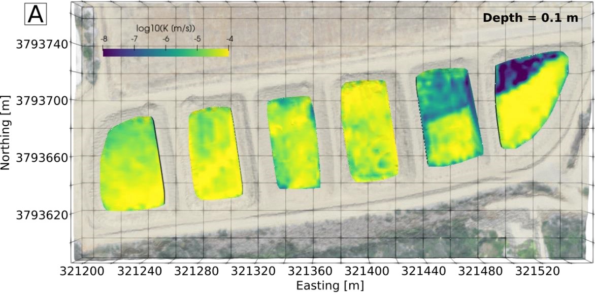
Soil permeability measurements were collected in Ponds 8 -13 with a soil permeameter and were coupled with the electromagnetic induction results to estimate the spatial distribution of hydraulic conductivity (K), that resulted in maps of permeability variation (shown in the maps below, yellow = high K).
The permeability maps were then used as inputs into a Hydrus 1D model for all of the ponds to estimate recharge rates (cm/hr). Recharge rates on the north end of Pond 9 were below 0.5 cm/h compared to infiltration rates on Pond 10 that ranged from 6.5 – 26 cm/hr, an order of magnitude higher. But the south end of Pond 9 has similar infiltration rates as Pond 10 due to the presence of the surficial sands (shown in this figure to the left).
The infiltration results were then evaluated in 3D. The image to the right shows 2D ERT results with the shallow sandy layers in 3D for perspective. The north end of Pond 9 has ~1.5m of clayey soil over a sand layer. Simulations of removing the clayey soil layer improved the infiltration capacity of Pond 9 by 184%. Which is similar to the infiltration rates in Pond 10. Therefore, a minimal modification to Pond 9 resulted in drastic improvement in recharge capability.
This study has shown how this approach not only characterizes the subsurface in great detail and can provide valuable information for further recharge study design, but it has also visualized how water migrates through the subsurface via preferential flow paths to deep aquifer recharge without flowing back into the river after infiltration. Furthermore, the results have shown that this strategic approach of data integration such as soil moisture, Ksat, amount of applied water, soil temperature and texture provide a number of physical and hydrological parameters that can be used in simple to complex models to quantify recharge in 1D, 2D, and 3D.
Importantly, this study also provided a workflow to assess basin modifications for improvement of recharge potential.
This approach is a valuable toolbox for water resource management into the future, during an uncertain water stressed future. In addition to understanding recharge at a single site, this pilot study also provides a cookbook (image to the right) approach that can provide valuable data to the region, and the state at large, on recharge performance in floodplain settings within certain soil types. These datasets can be very valuable when performing large scale basin forecasting because they provide ground-truthed data.
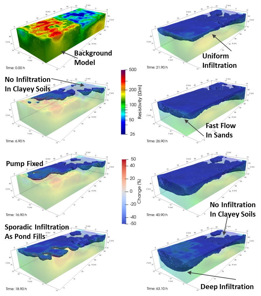
Recharge ERT Timelapse at Pond 9.
Recharge ERT Timelapse at Pond 10.
Videos show initial ERT model shows the soil type distributions followed by the Percent Change in resistivity from the initial starting model. The isotherms are what is greater than 15% negative change, associated with increased saturation in those zones.
Related Publications
Uhlemann, S., Ulrich, C., Newcomer, M., Fiske, P., Kim, J., & Pope, J. (2022). 3D hydrogeophysical characterization of managed aquifer recharge basins. Frontiers in Earth Science, 10, 942737. (link)
Ulrich, C., Uhlemann, S., Newcomer, M., & Fiske, P. (2022). Arroyo Las Posas Stormwater Diversion Feasibility Study and Percolation Test. Lawrence Berkeley National Laboratory Final Report, submitted to County of Ventura, Public Works. (link)